
Annapurna Circuit Trek
 📷
Show all 6 photos
📷
Show all 6 photos
- Trip Duration: 12N / 13D
- Max altitude: 5,418 m / 17,775 ft
- Grade: Difficult
- Start/End point: Pokhara
Annapurna Circuit Trek: The Ultimate Classic Himalayan Adventure
Considered one of the greatest treks in the world, the Annapurna Circuit Trek is the quintessential Himalayan adventure. Often referred to as the crown jewel of Nepal trekking, this 155 km journey takes you through two distinctly different regions: the culturally rich, Tibetan-influenced Manang Valley and the high-altitude, cold desert of the Mustang Valley.
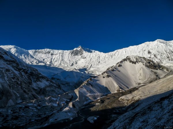
This once-in-a-lifetime expedition takes you from dense lush green forests, paddy fields, and the world’s deepest river gorges, all the way up to barren arid cliffs, glacial lakes, and the legendary Thorong La Pass at 5,418 meters. With the magnificent Annapurna Massif as your constant companion, this photogenic corridor is a paradise for serious mountain lovers and landscape photographers.
Overview
Best Time to Visit: April and October
The Annapurna Circuit Trek is done in 2 seasons – Spring (April) and Autumn (October).
During these 2 seasons, the weather in relatively stable with clear blue skies, limited rainfall, and spectacular views of the mountains. During the daytime in Autumn season, the temperature will be around 15°C whereas at night, the temperature will drop down to 0 °C. During the Spring season, the daytime temperature is around 15°C but at night, the temperature will drop down to 0 °C.
Difficulty Level: Difficult
Annapurna Circuit Trek is a difficult level trek so definitely not for the beginners. Moreover, you should only go for this trek, if you have previously gone for atleast 1 high altitude Himalayan trek. the total distance travelled in this trek is 155 km and the highest altitude attained is 5418 m in a span of 10 days which is absolutely no joke.
Hence there will be high chances of AMS and physical fatigue in this trek. So please make sure you are physically fit before coming for this trek. The trail also involves long and steep ascents and descents, walking through uneven terrain, and also narrow and rocky pathways. Though there is no technical climbing or mountaineering skills involved in this trek but the trail is physically draining.
Suitable Age Group:
The Annapurna Circuit trek is suitable for the age group between 13 to 60 years. The Annapurna Circuit Trek involves long walking hours hence it is mandatory that your fitness level should be at its peak. If you are below 18 years old, you should accompany your parents or guardian on this trek. If you are above 50 years of age, you need to carry a medically fit certificate from a doctor in order to go on this trek.
Pick Up point- Pokhara (Nepal)
Drop point- Muktinath (Nepal)
Pick-Up and Drop Time:
On Day 1, you should arrive in Kathmandu as per your schedule and contact our Altitude team. On Day 2, our journey for the Annapurna Circuit trek will start from Kathmandu at 9 am after breakfast. On the last day, we will reach Muktinath by 2-3 pm however we suggest making your further plans the next day.
How to Reach
Via Flight:
The easiest option is to fly to Kathmandu from major Indian cities such as Delhi, Mumbai or Kolkata, and then take a short domestic flight from Kathmandu to Pokhara International Airport (PKR). The Kathmandu–Pokhara flight takes around 25–30 minutes.
Via Train:
Pokhara does not have a direct railway connection. From India, you can take a train to Gorakhpur (GKP), the nearest major railhead, then continue by road to the Sunauli–Bhairahawa border and onward to Pokhara.
Via Road:
From India, one of the most convenient routes is Gorakhpur → Sunauli Border → Bhairahawa → Palpa → Pokhara. The Sunauli–Pokhara route is approximately 185 km, making it a popular overland option for travellers entering Nepal from North India.
Mobile Network Availability: NCell, the local network is available for most of the areas in the Annapurna Circuit trek. Both network signal and mobile data are available in most of the villages and majority of the trail. The best signal you will get is till Manang however the signal is patchy or completely gone when you will be in the high altitude areas of the trek especially in Thorong Phedi. You will also get good wifi services in the teahouses or mountain lodges.
Highlights
- Unrivaled Mountain Panoramas: Stunning views of the Annapurna Range, Dhaulagiri, Machupuchare, Manaslu, and Gangapurna.
- Thorong La Pass: Experience the ultimate adrenaline rush crossing one of the highest trekking passes in the world (5,418 m).
- Glacial Alpine Lakes: Trek to the electric blue waters of Tilicho Lake (4,919 m) and the serene Ice Lake (4,620 m).
- Diverse Landscapes: Transition from the lush Marsyangdi Valley to the arid, cold-desert landscapes of Manang and Mustang.
- Cultural Immersion: Experience rich, ancient Buddhist traditions, fluttering prayer flags, and unique teahouse hospitality in remote Nepali villages.
Itinerary
-
On the first day, you need to arrive in Pokhara (822 m) on your own. You can avail different ways to reach Pokhara as per your feasibility. We advise you to reach Pokhara by 4 pm and meet our team at Pokhara Hotel. You can also enjoy the boat ride on Pokhara Lake and enjoy the stunning sunset from the lake over the mountains surrounding. Pokhara is also a nice place to explore with numerous cafes and local shops. Overnight stay in a hotel.
-
On the 2nd day, we will drive from Kathmandu (1300 m) to Chame (2710 m) via Besisahar. The distance travelled today is 238 km which will take around 9.5 hours to reach. We will start early after breakfast as it will be long journey today. We will have our lunch in Besisahar which is 6 hours journey from Kathmandu. The condition of roads from Besisahar to Chame is not good but at the end of this rough road you will enter a beautiful village in the Manang district. The route that goes to Chame is all along the west bank of the River Marsyangdi. Chame is a beautiful less populated village that has stone and mud houses painted in bold colours. After 3 hours of drive, we will come near Chame. It is here we will see the Chamje Waterfalls and is a nice spot to spend some time. If you arrive before the sunset, do not miss the magical sunset when the sunlight falls on Manaslu North, Manaslu, and Phungi Himal and looks like painted in fiery red in the twilight. Night stay at a mountain lodge in Chame.
-
On the 3rd day, our trek finally starts. Today we will trek from Chame (2710 m) to Upper Pisang (3310 m). The distance travelled is 15 km which will take around 5-6 hours. Do not miss the magical sunrise in Chame. Chame is a gifted village with a landscape to die for. When the first morning light falls on Lamjung Himal, it gives you the perfect motivation for the entire day. If you want you can go to Chame View Point which is a small 2 hours hike in the early morning. From the View Point you will get some unobstructed views of Lobuche Peak, Annapurna II, Manaslu North, Phungi Himal, Lamjung Himal, and Manaslu. With such magnificent views we will start our trek today. The trail starts with a gradual climb amidst alpine trees and Mani Stones and Chortens are present on the trail. After 3 hours of trek we will cross a suspension bridge to move the other side of the river flowing below. After this there will be gradual to steep ascent. From here we will get excellent views of Paungda Danda and Pisang Peak. There is also a dove-shaped pond known as Dhukure Pokhari. From here after 1 hour of trek comes a point where there are 2 trails – one goes to lower Pisang and the other goes to Upper Pisang. We will take the one take will go to Upper Pisang right below the Pisang Peak. So you can imagine the beauty of this campsite. Night stay at Upper Pisang.
-
On the 4th day, we will trek from Upper Pisang (3310 m) to Ngawal (3660 m). The distance travelled today is 10 km which will take 6 hours to reach. Wake up with the magnificent views of Annapurna II in Upper Pisang. After breakfast, we will start our trek. our first stop will be at Ghyaru. Ghyaru is an excellent point to take rest spectacular views of Annapurna II, III, and IV. Ngawal is at a lower elevation from Ghyaru with a downhill climb. Today is one of the most picturesque day so if you have interest for photography, there will be many stop. The entire frame looks spectacular with Annapurna II in sight along with other high peaks surrounding the sprawling valley and the forest-covered slopes just above the valley. Please be very careful as there will be altitude gain hence chances of occurrence of AMS is high. Night stay at a mountain lodge in Ngawal.
-
On the 5th day of our trek, we will trek from Ngawal (3660 m) to Bragha (3470 m). The distance travelled is 8.5 km which will take around 3.4 to 4 hours to reach. Initially there will be a forest trail till we reach Braga. Braga is the last village before Manang. You can find a small café in the jungle where you can stop for some refreshments. Packed lunch will be provided to you. The landscape from Ngawal to Bragha is very beautiful which you can enjoy at your ease while walking through the trail. Braga is a small village near the Ice Lake. Night stay at Braga in a mountain lodge.
-
On the 6th day of our trek, we will trek from Braga (3470 m) to Ice Lake (4620 m) and back to Bragha and from there will trek to Manang (3540 m). The distance from Braga to Ice Lake is 7 km and back to Braga is another 7 km which will take 8 hours to complete the round trip. From Braga to Manang is 2 km which will take 30 minutes to 1 hour. Today is a long day hence we will start our trek early in the morning. The Ice Lake which is also known as Kicho Tal is a high alpine lake located above the Manang Valley which is a part of the Annapurna Conservation Area. The trail involves steep ascent along with alpine shrubs at the side. There is a chance of spotting Blue Sheep and Himalayan Monal on the way. Though the trail is tiring due to the steep climb the view is sensational. Finally, when you reach Ice Lake, there will be a praying structure which is very small beside the lake with vibrant prayer flags fluttering all around the lake. Now the view of the snow-capped high mountain peaks from Ice Lake is beyond explanation and riveting. The peaks visible from here are Annapurna III, Gangapurna, and Kangsar Kang. The unparalleled view from the lake will make you forget all the toils you have faced while reaching for the lake, that’s for sure. The turquoise colour water of the lake adds to the overall beauty of the place. After spending some quality time, we will start our trek back to Braga. From Braga, Manang village is not far and will take 30 minutes to 1 hour to reach. Manang is the largest in the Annapurna Circuit trail and is a picturesquely beautiful village with amazing landscapes all around. Night stay at a lodge in Manang.
-
On the 7th day of our trail, we will trek from Manang (3540 m) to Shree Kharka (4045 m). The total distance travelled today is 7 km which will take 4 hours to reach. Today won’t be a long tiring day like yesterday. Wake up at Manang with the magnificent view of Gangapurna and the glaciers beside the peak. We will start our trek after breakfast. The moment you leave the village, you will come at a point from where you will get stunning views of Annapurna II, III, and IV completely snowclad. With the river snaking out beside the lush green fields below, the brown colour stone houses of Manang in the middle, and at the top there is snowclad high mountain peaks – the overall view is beyond a fairytale dream that is overwhelming yet extremely humbling. This point will surely delight your mountain-loving heart. After walking for some time, we will reach Kangsar village which has plenty of houses. You can stop by for a cup of tea and take some rest while enjoying the view. From Kangsar there is a steep climb of 200 meters and from there a gradual uphill climb all towards Shree Kharka. We will stay at a mountain lodge in Shree Kharka. You can use the rest of the day to explore the village at your leisure.
-
On the 8th day of our trek, we will trek from Shree Kharka (4045 m) to Tilicho Base Camp (4140 m). The distance travelled today is 7 km which will take 3 hours to reach. Today’s trail on the mountains will make you spot Blue Sheep and Mountain Goats. We will start early after breakfast and initially there is a steep climb of 100 m after which there the trail is like the hump of a camel, up and down for some time. After this we will cross a bridge over a deep gorge with the sound of the river underneath. The landscape today is massive with arid lands and the mountains are like the pillars of mud similar to termite mounds. This distinctness adds a touch of drama to the landscape. Once we cross the village, the uphill climbing is quite precarious as the barren trail is on a crumbling mountain. Today’s trail is quite different from the ones you witnessed earlier with no vegetation, dry and arid area where the mountains have different shades of brown instead of green and white. The more you go ahead of the trail, you will feel like you are in a different planet altogether. The local people in these remote areas speak different languages and have different cultures. Finally, we will reach Tilicho Base Camp before noon. Overnight stay in tents at Tilicho Base Camp.
-
On the 9th day of our trek, we will trek from Tilicho Base Camp (4140 m) to Tilicho Lake (4920 m) and back to the base camp and from there will trek back to Shree Kharka (4045 m). The total distance travelled today is 18 km which will take around 10 hours. Today is another long trekking day like the one when we visited Ice Lake. Today we will start even before the sunrise so that everything goes smoothly according to the plan. We gather all our strength early morning to visit Tilicho Lake which is a glacial alpine lake with electric blue colour water. The beauty of the lake is something that cannot be described in words and only to be felt by being on the spot. The lake is at an high altitude of 4920 m which is beautifully surrounded by snow laden landscape. The trail to the lake involves steep uphill climbing on l.oose moraine. So please be very careful. We should start our trek by 4.30 am and will carry packed breakfast. You will find frozen dew drops on the trail as the temperature will be freezing cold at such an hour. When the first rays of sunlight falls on the mountains surrounding the beauty delivered is surreal. There will be several hair pin bends towards the lake and after climbing for 2.5 hours we will enter the snow area. Here there is a steep climb when we finally see the board written Tilicho Lake in white and blue. The lake is another 1 hour away from here and the trail is covered in snow. It seemed like a white carpet has been laden in front of you. Finally we get to see the electric blue waters of the Tilicho Lake and seeing its beauty you would understand how all the hard work is absolutely justified with the beauty in front of you. Hundreds of vibrant prayer flags are fluttering all around the lake and there is a small temple right beside the lake. The view from the lake is unbeatable. The peaks that are visible from the lake are Annapurna, Gangapurna, Nilgiri, Tilicho Peaks, and Khang Sar. After spending some quality time beside the lake, we will head down to the base camp using the same route. It will be a downhill climbing in snow so please be very careful. After 2 hours we should reach the base camp and will have our lunch and freshen up and take some rest. After that we will start moving towards Shree Kharka. The trail to Shree Kharka which is 7 km away won’t take much as it will be again downhill climbing and our bodies will be at ease as we will lose altitude. The trail near Shree Kharka is very narrow and dusty. Finally, we will reach Shree Kharka after a long day and rest in a mountain lodge. Two major days in ACT have been successfully completed and witnessing the high mountains so close is an overwhelming feeling.
-
On the 10th day of our trek, we will trek from Shree Kharka (4045 m) to Yak Kharka (4020 m) or Letdar (4230 m). The distance travelled is 10 km till Yak Kharka and another 3 km if we go to Letdar. While descending at first we will cross the Khangsar village and Tare Gumpa which is a 1000 year old monastery. Then there will be a bridge that will enter to the Thorong Khola valley. Today the trail is not much difficult and involves gradual ascent and descent but since we are at high altitude it will be physically tiring. If time permits we will move to Letdar or else we will stay at Yak Kharka.
-
On the 11th day of our trek, we will trek from Yak Kharka or Letdar to High Camp (4850 m) via Thorang Phedi (4540 m). The distance travelled is 6 km but due to considerable altitude gain it will take around 5 hours to reach. Today the high altitude will slow you down. We start early today and initially there will be a steep climb which will take around 40 min and after that there will be a small flat patch. Do not forget to capture the mindboggling view from here with Annapurna III and Gangapurna decked up in bright shades of red early in the morning being another memorable sunrise. This out of the world sight should not be missed. There will be a river crossing post which another steep climb is there. The distance from Letdar to Thorang Phedi is 5 km which will take almost 2.5 hours. Thorang Phedi is full of ridges, crags, and cliffs. We will move ahead from Thorang Phedi to High Camp. There is another steep climb to High Camp but reach as soon as possible as there is limited options of lodging at High Camp. However, you will be delighted to find the quality of stay and food at High Camp which is located at such a remote place in a high altitude. Acclimatize as much as possible at High Camp which will help you for the next day. Night stay at a mountain l.odge in High Camp.
-
Today is the last day of our trek and marks another important day. We will trek from High Camp (4850m) to Muktinath (3800 m) via Thorung La (5418 m). The total distance travelled today is 15 km which will take 7 hours to reach. Today we will attain the maximum altitude gain so please mind your steps very carefully or else the chances of AMS are very high. Today is another day when we start early 5 am after breakfast. The trail in the dark will be zig zag and very narrow amidst ice and moraine patches. So you need to be extra cautious while walking. This tough trail will continue for 2 hours. Please make sure to carry 2 litres of water as you will feel thirsty in such high altitude and thin air. Do not get dehydrated. The locals call this enchanting place as the home of the Gods and truly when the first rays of sunlight falls on Annapurna III and Gangapurna, it literally justifies their statement. The different shades of red and orange you will see over the snow-capped mountains will actually fall short of colours. There will be quite an amount of snow when you finally enter Thorung La. The pass is 4 km long which will take 3 hours. Do not rush and listen to calls of your body because the most crucial part now is the high altitude and thin air. Numerous prayer flags are surrounded all over and brutal winds are blowing which will literally freeze you. The trail down to Muktinath through cold deserted mountains is very tiring. Make a stop at the Kali Gandaki Valley and admire its breathtaking landscape and beauty. From here you will get the best view of Dhaulagiri in your entire trek. check in to a hotel in Muktinath. Our journey finally ends here and we advise you to make your return plans from the next day onwards.
-
We advise to keep a buffer day in this trek for any unforeseen situations. Our trek leader will guide you properly in any adverse situation. Buffer day can be used anywhere in the trek as per expert’s decisions. You can also explore Muktinath or Pokhara and relax. Cost of the buffer day is excluded.
Get an out of the world experience by going for Annapurna Circuit Trek only with Altitude Adventure Holidays!!!
What's Included
- Accommodation at Pokhara & Muktinath (hotel or guest house).
- Accommodation while trekking at tea house.
- Transportation from Pokhara to Chame.
- All meals (Breakfast, lunch, dinner, 2 times tea/coffee) while on trek.
- Trekking Permits.
- First aid medical kits.
- Trek equipment like sleeping bags (for those who dont have their own), mattress etc.
- Experienced Trek Leader, one local guide.
What's Not Included
- Porters/Mules to carry personal luggage (Available at an extra cost).
- Transportation from muktinath to pokhra.
- Food during the transit.
- Insurance for clients.
- Anything not specifically mentioned under the head.
Frequently Asked Questions
The Annapurna Circuit is classified as a difficult trek. While it doesn't require technical climbing skills, it is physically demanding due to long walking hours (6–8 hours a day), steep ascents, and the high risk of Acute Mountain Sickness (AMS) at altitudes above 3,000 m.
It is not recommended for absolute beginners. Due to the 5,000 m+ altitude and the 155 km distance, trekkers should have prior experience with at least one high-altitude Himalayan trek and a high level of cardiovascular fitness.
Tilicho Lake (4,919 m) is a popular side trip or "add-on" to the main Annapurna Circuit. While it adds about 2-3 days to the total itinerary, it is highly recommended for its stunning electric-blue water and superior acclimatization benefits.
Yes, two permits are mandatory:
1. ACAP (Annapurna Conservation Area Permit)
2. TIMS (Trekkers' Information Management System) Card These are typically arranged by your trekking agency.
The trail is famous for its Teahouses—mountain lodges that provide a bed and hot meals. While rustic, many now offer amenities like hot showers, charging stations, and even "World's Highest" bakeries serving fresh apple pie.
Common symptoms include persistent headaches, nausea, dizziness, loss of appetite, and shortness of breath. To prevent AMS, we follow the "climb high, sleep low" rule and include mandatory acclimatization days in Manang.
⭐ Verified Feedback
Customer Reviews & Experiences
🪙
Earn 500 Coins (Worth ₹50.00) for a 5-Star Review!
Share your journey! Every customer who gives a 5-star review will automatically have 500 Coins credited to their Reward Wallet.
Be the first to review “Annapurna Circuit Trek”Cancel Reply
Gear Checklist
Trekking pole
Water bottle
Head lamp
Sunglasses
Power bank
Rain cover for rucksack
Windproof jacket
Sun cap
Trekking shoes
Sunscreen lotions
Booking Form
Customize this
- Trip Duration: 5N / 6D
- Max altitude: 3,636 m (11,929 ft)
- Grade: Beginner
- Start/End point: NJP / Siliguri
₹13,000.00 +5% GST
🪙Earn 1,300 Coins (Worth ₹130.00) with this booking!
- Trip Duration: 6N / 7D
- Max altitude: 4,500 M (14,764 ft)
- Grade: Moderate
- Start/End point: Pokhara
₹17,000.00 +5% GST
🪙Earn 1,700 Coins (Worth ₹170.00) with this booking!
- Trip Duration: 14N / 15D
- Max altitude: 5143 M (16,873 ft)
- Grade: Hard
- Start/End point: Njp
₹38,000.00 +5% GST
🪙Earn 3,800 Coins (Worth ₹380.00) with this booking!
- Trip Duration: 13D / 12N
- Max altitude: 5359m / 17582ft
- Best Time: June – September
- Start/End point: Srinagar
₹41,000.00 +5% GST
🪙Earn 4,100 Coins (Worth ₹410.00) with this booking!
- Trip Duration: 5D / 4N
- Max altitude: 4270 m / 14,065 ft
- Grade: Easy to Moderate
- Start/End point: Manali
₹13,000.00 +5% GST
🪙Earn 1,300 Coins (Worth ₹130.00) with this booking!
- Trip Duration: 19D / 18N
- Max altitude: 5,560m / 18,242 ft
- Grade: Hard
- Start/End point: Kathmandu
₹60,000.00 +5% GST
🪙Earn 6,000 Coins (Worth ₹600.00) with this booking!
Reviews
There are no reviews yet.